


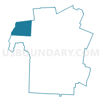
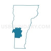
Benson Voting District, Rutland County, Vermont
About
Outline

Summary
| Unique Area Identifier | 680877 |
| Name | Benson Voting District |
| County | Rutland County |
| State | Vermont |
| Area (square miles) | 45.52 |
| Land Area (square miles) | 43.98 |
| Water Area (square miles) | 1.54 |
| % of Land Area | 96.62 |
| % of Water Area | 3.38 |
| Latitude of the Internal Point | 43.71036350 |
| Longtitude of the Internal Point | -73.30253580 |
Maps

Graphs
Select a template below for downloading or customizing gragh for Benson Voting District, Rutland County, Vermont


Neighbors
Neighoring Voting District (by Name) Neighboring Voting District on the Map
- Voting District 030001, Washington County, NY
- Voting District 140001, Washington County, NY
- Castleton Voting District, Rutland County, VT
- Fair Haven Voting District, Rutland County, VT
- Hubbardton Voting District, Rutland County, VT
- Orwell Voting District, Addison County, VT
- Sudbury Voting District, Rutland County, VT
- West Haven Voting District, Rutland County, VT
Top 10 Neighboring County Subdivision (by Population) Neighboring County Subdivision on the Map
- Castleton town, Rutland County, VT (4,717)
- Fair Haven town, Rutland County, VT (2,734)
- Orwell town, Addison County, VT (1,250)
- Benson town, Rutland County, VT (1,056)
- Hubbardton town, Rutland County, VT (706)
- Dresden town, Washington County, NY (652)
- Putnam town, Washington County, NY (609)
- Sudbury town, Rutland County, VT (560)
- West Haven town, Rutland County, VT (264)
Top 10 Neighboring Place (by Population) Neighboring Place on the Map
Top 10 Neighboring Elementary School District (by Population) Neighboring Elementary School District on the Map
- Castleton-Hubbardton Union School District 42, VT (5,423)
- Fair Haven School District, VT (2,734)
- Orwell School District, VT (1,250)
- Benson School District, VT (1,056)
- Sudbury School District, VT (560)
- West Haven School District, VT (264)
Top 10 Neighboring Secondary School District (by Population) Neighboring Secondary School District on the Map
- Fair Haven Union High School District 16, VT (10,727)
- Otter Valley Union High School District 8, VT (9,200)
Top 10 Neighboring Unified School District (by Population) Neighboring Unified School District on the Map
Top 10 Neighboring State Legislative District Lower Chamber (by Population) Neighboring State Legislative District Lower Chamber on the Map
- Assembly District 112, NY (139,495)
- Rutland-2 State House District, VT (8,421)
- Addison-Rutland-1 State House District, VT (3,990)
- Rutland-6 State House District, VT (3,551)
Top 10 Neighboring State Legislative District Upper Chamber (by Population) Neighboring State Legislative District Upper Chamber on the Map
- State Senate District 45, NY (306,856)
- Rutland State Senate District, VT (57,676)
- Addison State Senate District, VT (40,787)
Top 10 Neighboring 111th Congressional District (by Population) Neighboring 111th Congressional District on the Map
Top 10 Neighboring Census Tract (by Population) Neighboring Census Tract on the Map
- Census Tract 9609, Addison County, VT (5,337)
- Census Tract 9636, Rutland County, VT (4,717)
- Census Tract 9637, Rutland County, VT (2,734)
- Census Tract 9623, Rutland County, VT (2,586)
- Census Tract 820.02, Washington County, NY (1,261)